Sendero del cerro del Cinto
| Sendero del cerro del Cinto | ||||||||||||||||
 |
||||||||||||||||
| |
||||||||||||||||
operating instructionsVarious functions are available as part of the map. mouse/touch operation
keyboard operationKeyboard operation becomes available after activating the map using the tab key (the map will show a focus indicator ring).
It's possible that some of the functions or buttons describe above have been disabled by the page author or the administrator
|
||||||||||||||||
| Descargar GPX | ||||||||||||||||
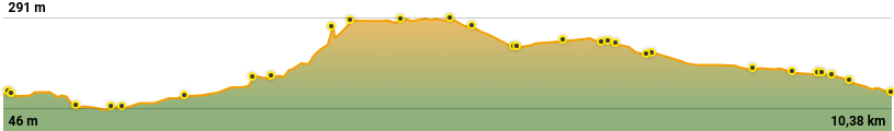
| Lugar: | Níjar | |||||||||||||||
|---|---|---|---|---|---|---|---|---|---|---|---|---|---|---|---|---|
| Distancia: | 10,5 Km | |||||||||||||||
| Duración aproximada: | 3,5 h | |||||||||||||||
| Más detalles: | Senderos de Almería | |||||||||||||||


